The Skidaway Institute of Oceanography is expanding its coastal radar system with the addition of a new send-receive station on Jekyll Island. The radar system, called WERA, is used to study surface ocean currents on Georgia’s continental shelf and out as far as the Gulf Stream.
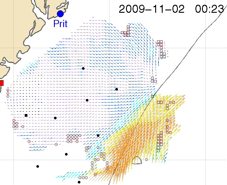
The Jekyll Island unit is the third station in the system. Two original stations were installed on Pritchard Island, S.C. and on a coastal island south of Savannah. The three systems work together to create a detailed map of surface ocean currents across an area stretching more than 125 miles off shore from South Carolina to North Florida. The map consists of hundreds of data points on the ocean surface which are updated twice an hour. The map shows the speed and direction of the surface current at each of those points.
The equipment was purchased with a grant from the Georgia Research Alliance, combined with funding allocated by South East Atlantic Coastal Ocean Observing System.
“Measurement of surface currents and waves has a broad range of economic, societal, research and educational applications,” said Skidaway Institute professor Dana Savidge.
Those include search and rescue operations; tracking and predicting the trajectories of oil spills and pollutants; maritime operations; commercial and recreational fishing and boating; ecosystem assessment; and improving our understanding of the response of the coastal ocean circulation to major winter storms or hurricanes.
Aside from the practical applications, Savidge says the primary purpose of the system is to improve researchers’ understanding of what is happening on Georgia’s continental shelf.
“The ocean continues to be very poorly observed,” she said. “For example, we do not know how material from the land crosses the shelf. It may be organic. It may be manmade. It may be pollutants. Where does it go and how does it get there? These measurements will help us find out.”
The new site will significantly increase Savidge’s ability to study eddies that develop at the juncture of the shelf edge and the Gulf Stream. These eddies may affect the supply of nutrients available to marine life in that area of the ocean.

The radar data can been seen as a map, with the color, length and direction of the arrows showing the velocity of the surface currents. The orange and yellow arrows on the bottom right indicate the Gulf Stream.
There are presently approximately 100 similar radars operating throughout United States. The installation on Jekyll Island will greatly increase coverage to include the entire Georgia shelf and northern Florida. It will add critical overlapping redundancy with existing installations, providing essential two-installation operation during periods when one installation of the three may go down due to lightening strikes, power outages or other problems.
The new radar system is located at the Villas by the Sea condominiums on the north end of Jekyll Island.
“We can’t say enough about how great the folks at Villas by the Sea have been to work with us on this and allow us to install our antennas there,” said Savidge.
Savidge also praised research coordinator Trent Moore who she said, “has shouldered a very long term commitment and wrestled this thing through multiple stages, none of which are shy of endless details and physical efforts.” Skidaway staffers Jay Fripp and Harry Carter also contributed to the project.
Data from the radar system can be seen at the Skidaway Institute Web site. ![]()


